


Sampling points
11 stations around main basin of Isfjorden were revisited. Using methodology applied in previous survey enable comparison of those two datasets. On this basis it is possible to infer on dynamics of the Isfjorden coastal ecosystem.
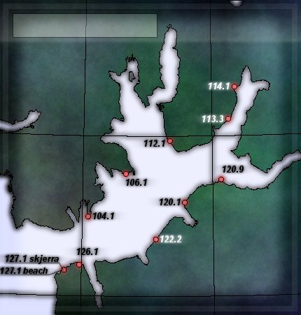
List of sampling points revisited during Isfjorden 09 expedition.
| no. | Station code | Geographical name | Longitude | Latitude |
| 1 | 104 1 | Erdmanpynten | N78 14.900 | E14 05.290 |
| 2 | 106 1 | Bochemanfl | N78 22.920 | E14 39.660 |
| 3 | 112 1 | N78 29.130 | E15 20.530 | |
| 4 | 113 3 | N78 33.156 | E16 15.348 | |
| 5 | 113 4 | PIRAMIDEN | N78 39.180 | E16 21.880 |
| 6 | 120 1 | Revnesset | N78 17.600 | E15 34.070 |
| 7 | 120 9 | Diabas | N78 21.840 | E16 07.890 |
| 8 | 122 2 | Grumant | N78 10.728 | E15 07.446 |
| 9 | 126 1 | N78 05.810 | E13 57.930 | |
| 10 | 127 1 a/b | N78 04.780 | E13 44.450 |
Locations of points where samples for SIP were collected (yellow - sand or gravel; red - bedrock).
Photos of sampling stations
Select point:
Click wherever to close this map
Go to: ...
Go to: ...