About the project
Land promontories as coastal biota monitoring sites on Spitsbergen. Job for citizen scientists.The climate change drives the change of coastal – intertidal ecosystem on Svalbard. This is partly driven by the ice retreat, temperature rise, but first of all by the advection of waters from the south. Boreal species, marine litter, driftwood etc floats with the sea currents and reach Spitsbergen shores, touching the land extensions first. Peninsulas, capes, especially at South- West and North Spitsbergen are the indicative sites for this southern transport. From the genetic analysis of boreal organisms found on the Spitsbergen shores, we know, that species arrive from the wide area of North Atlantic, from North America, Iceland, Scotland, Faroe and Norway. This provides the genetic diversity and wealth of possibilities for colonization the Arctic shores. We plan to document the significance of selected land promontories for the early detection of new species arrival as well as the plastic litter loads. The litter issue is of special importance for Svalbard, as plastic transport will be likely increasing, and European Arctic is commonly referred to as a “dead end” of Atlantic litter transport.
The result of the project will be a detailed background info that will permit to follow the coastal ecosystem change that is driven by advective transport from the South. From the ten proposed sites, we will select three to four which are most representative as natural traps for drifters and those shall be monitored every 3 to 5 years to follow the changes. We will present the measure, indices and methodology for such monitoring, based on Norwegian and EU experience in this field. Most of such monitoring can be easily performed by the local “citizen science” initiatives, as the key information are the coastal photography, macro litter inspection and collection easy to spot organisms for the genetic control. These will give better prediction for the consequent coastal change in the fjords and inland waters of the archipelago.
Work plan
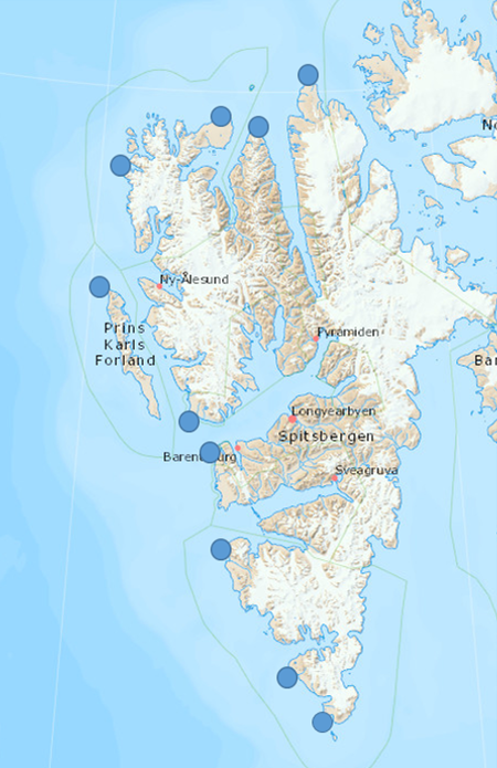
We want to document in detail the ten selected land promontories of Spitsbergen (Table and Fig ). Along 1km long coastal units in each site the description of geomorphology of the coast, the intertidal and near-coast vegetation, micro and meiofauna of the sediment and soil, litter of all kinds deposited. For such small units as detailed as possible the species inventories will be prepared. The assessment of coverage and biomass of plant – algal life will be documented. For the selected key genera (Littorina, Gammarus, Semibalanus, Mytilus, Fucus) the genetic analyse will be performed to detect their relation to source area and dispersal. Besides descriptive analyse of the cost units, the medium scale (Spitsbergen coastal waters) hydrodynamic modelling will be conducted to demonstrate the most likely pathways of the drifting objects to the shore.
Table 1
Land promontories on Spitsbergen – the early warning stations for drifters
| nr | place name, region | latitude | longitude |
| 01 | Oyrlandsodden, Sorkappland | 76°34 | 16°16 |
| 02 | Palffyodden, Sorkappland | 76°53 | 15°30 |
| 03 | Straumnesset, Weddel Jarlsbergland | 77°31 | 13°54 |
| 04 | Revleodden, Nordenskjoldkysten | 78°02 | 13°34 |
| 05 | Kapp Scania, Isfjorden | 78°12 | 13°03 |
| 06 | Fuglehuken, Prins Karl Forlandet | 78°53 | 10°28 |
| 07 | Kvalryggpynten, NW Spitsbergen | 79°33 | 10°39 |
| 08 | Velkomspynten, N Spitsbergen | 79°52 | 13°43 |
| 09 | Grahuken, Wijdefjorden | 79°47 | 14°31 |
| 10 | Verlegenhuken, N Spitsbergen | 80°03 | 16°14 |
Fig. 1
Localisation of potential monitoring sites
|
|
Related projects web pages run by Institute of Oceanology PAN https://old.iopan.pl/projects/Acces/ https://old.iopan.pl/projects/Adamant/ https://old.iopan.pl/projects/SIP/index.html Coastal data base constructed from the above projects https://adamant.iopan.pl/adamant/taxa_observations/ |